


From Early Fire Towers to the Great Lighthouses of Antiquity
Ulysse Allais
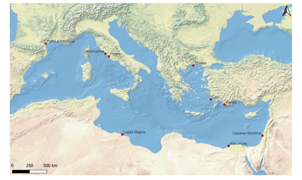
In the Mediterranean, from the first fire towers of the Greek Archaic period to the monumental lighthouses of the Roman Empire, these maritime signaling devices underwent major historical, technical, and functional evolutions. But how did these structures transition from landmarks to essential tools for maritime safety and prestige? And how were they progressively and systematically integrated into the architecture and organization of major ports?
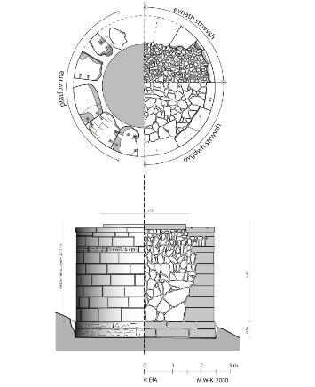
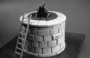
From the Archaic period (800-480 BCE), luminous structures installed on the coast allowed sailors to orient themselves and navigate at night1. On the island of Thasos, at the capes of Phanari (fig. 2 and fig. 3) and Pyrgos (fig. 4 and fig. 5), archaeologists have unearthed the remains of solid tower-like constructions bearing an open hearth at their summit. Dating to the 6th century BCE2, the Phanari lighthouse is built on a promontory 8.23 m above current sea level. It is made of gray marble blocks from a nearby quarry. Its location on the coast makes it visible from the sea over more than 180 degrees. Slabs of sandstone, a refractory rock, were placed in the center of the circular tower to support the hearth. The lighthouse’s dimensions are quite modest, measuring 3.50 m in diameter by 2.54 m in height. Because the monument was built without binding material, it held together by its own weight; the structure collapsed, undoubtedly due to an earthquake. Built during the same period, the Akeratos lighthouse is located on Cape Pyrgos at an altitude of 100 m. Also of modest dimensions—4.88 m in diameter by 3.45 m high—the structure’s stability was improved by chaining the ashlar stones forming the platform. This belt prevented the masonry from opening in the event of a traumatic event (landslide, earthquake). The crowning, secured in this way, prevented the masonry from splitting. However, the construction of these two towers shared the same weak point: an unbound internal core made of rough marble blocks, which led to their collapse.
It is in Cos that we find one of the first archaeological attestations of the installation of a lighthouse in a port environment. In 325 BCE, a Greco-Phoenician inscription records the dedication of a monument erected for “the salvation of all navigators”3. It seems logical that this was a tower, but the inscription does not specify the type and nature of the building4. This inscription reveals that the construction was commissioned by King Gerbaal, son of King Abdalonymus, king of the Sidonian people (Phoenicians), and that it is dedicated to the goddesses Astarte and Aphrodite5.
Half a century later, a similar formula is used for the dedication of the statue of the Lighthouse of Alexandria6: “Sostratus of Cnidus, friend of kings, for the salvation of those who sail” (Σώστρατος Κνίδιος, φίλος τῶν βασιλέων, τῆς τῶν πλοιζομένων σωτηρίας χάριν). Initially, the Lighthouse of Alexandria is described as a pyrgos (Strabo, Geography, III, 1, 9), that is, as a tower, a natural promontory, a lookout point for observing the sea. It is only from the end of the 1st century CE that the term φάρος (pharos) designates a maritime signaling device7.
In 297 BCE, Ptolemy I Soter ordered the construction of the Lighthouse of Alexandria (see The Lighthouse of Alexandria). It was erected on the eastern tip of the island of Pharos, located off the coast of Alexandria. The island is connected to the coast by a causeway-bridge called the Heptastadion, about 1 to 1.4 km long, thereby creating two large ports: one to the west and the other to the east. In his Geography (XVII, 1, 6), Strabo briefly describes the Lighthouse of Alexandria and outlines its primary functions: indicating the path to reach the coast, serving as a landmark at night, and pointing the direction to the port(s) of the ancient metropolis while avoiding the main coastal dangers. The Lighthouse of Alexandria “materializes low-lying lands that are invisible during landfall phases and indicates the dangers of the entrance pass, but not the port entrance itself”8. The function of the Lighthouse of Alexandria likely evolved over time, depending on the ruling powers and political and maritime needs.
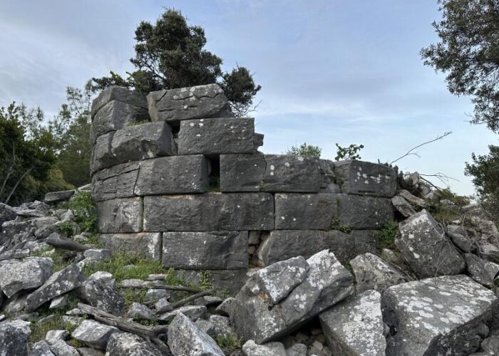
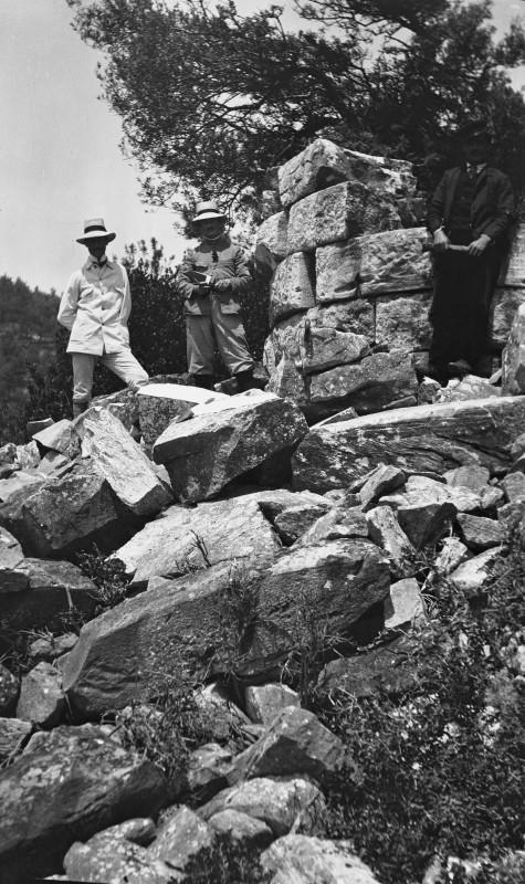
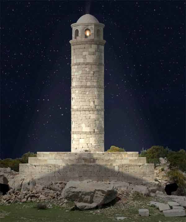
In the 1st century CE, a tower was built at the entrance to the Roman port in Patara, Lycia (fig. 6). It is one of the best-preserved ancient lighthouses in the Mediterranean9. It is located near the mouth of the Eşen River, the ancient Xanthos. This lighthouse was commissioned by the Emperor Nero. Executed by his legate Sextus Marcius Priscus, the project was financed by the Empire. The building consists of a 24.20 m high tower perched on a 2.30 m high stepped podium. It rests on a rocky outcrop measuring 20 meters on each side, west of the port entrance. The tower features a spiral staircase allowing access to the top and thick walls. It is estimated that about 80% of the masonry’s ashlar stones remain. Its main role is revealed by a Greek inscription10: “the lighthouse was built for the safety of sailors” (τὸν φάρον κατέσκευασεν πρὸ[ς ἀσ]φάλ[ει]αν [τῶ]ν πλοϊ[ζομένω]ν διὰ ). The tower was intended to signal the port entrance and guide ships toward the harbor from the open sea. A second inscription on the base of a statue of Priscus, dating to 70/71 CE, mentions the establishment of a complementary structure, an “antipharos,” built shortly after the lighthouse, whose exact location is unknown. It is presumed to be an unlit tower or a beacon rather than a second lighthouse. The Patara lighthouse operated until its collapse at the beginning of the modern era, potentially caused by a tsunami, as suggested by the damage observed on the podium (southeast side) and the tower’s direction of fall (toward the northwest). Although a date of 1481 has been suggested for its destruction, this is contested because the lighthouse reportedly appears intact on a map drawn by Piri Reis and dating to 1524. At the same time, studies show that the ancient port silted up after the 15th century, thus becoming a marsh11.
To allow for better docking, some ports multiplied their lighthouses, or at least their luminous landmarks. In a military context, having two towers makes it possible to control and close off access to ships, as is the case in the port of Piraeus12. But this organization is also attested in commercial ports like Caesarea Maritima.
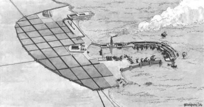
The port of Sebastos at Caesarea Maritima (fig. 7), for example, consists of a breakwater extending into the sea and including a series of towers13. These towers are an integral part of the quay structure. At the end of the northern mole, archaeologists have uncovered a large block of ancient concrete (11.5 m by 15 m) considered to be the potential foundation of the tower. On the southern mole, two very large isolated pillars, made of hydraulic concrete, have been interpreted as the foundations of two towers. The main breakwater encircling the port seems to use two lines of pilae, which are large blocks of hydraulic concrete. The outer row of pilae acted as a prokumai, or breakwater, to protect the port. The inner arch of pilae likely served as a foundation for the towers along the sea wall, while reinforcing the seaward face of the breakwater. Between these two lines of pilae, an infill made of kurkar (a local sandstone) forms a continuous structure, thus completing the breakwater. Thus, the towers become distinctive and important structural elements of the moles in the port of Sebastos, and mark the port entrance.
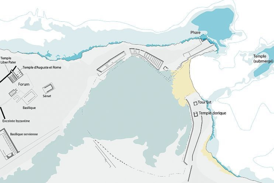
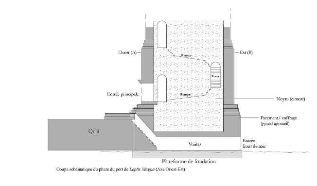
The case of the port of Leptis Magna also presents interesting characteristics (fig. 8 and fig. 9). Founded in the 7th century BCE, Leptis Magna is a Phoenician city in present-day Libya, 110 km east of Tripoli. Archaeologists have observed the remains of a monumental stepped lighthouse on the northwest quay, dating to the reign of Emperor Septimius Severus (193-211 CE)14. Furthermore, a small tower was unearthed on the quay facing the monumental lighthouse, likely serving as a signal light in the port.
As with Caesarea Maritima, the towers do not have military objectives and are not integrated into a fortification network, but they mark the port entrance. The monumental lighthouse is 35 meters high and thus projects its signal out to the open sea. For a ship to safely engage a pass securely, it is indeed necessary to have at least two lights—one to starboard and the other to port—thereby marking the entrance. This makes it possible to materialize the access bottleneck and mark its navigable limits. The monumental lighthouse ensured the range of its light across the open water, while the second tower probably completed the guidance system by signaling the threshold of the pass or the beginning of the access channel.
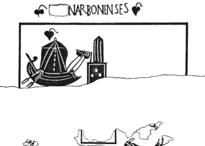
Located in the western Mediterranean, the site of La Nautique is the only formally identified ancient outer harbor of the Narbonne port system15, known since the medieval period under the name of Port de Capelles or Port des Galères. In 1998, archaeological soundings brought to light a submerged construction in large ashlar masonry: an alignment of wooden timbers encircling a structure16. Stratigraphic observations17 indicate that this submerged construction, which forms the foundation of a quay, was in use between the last two decades of the 1st century BCE and the middle of the 1st century CE. This quay is overhung by a structure covered with tiles: it has been interpreted as a possible lighthouse or, at least, a navigational mark (amer). The rectangular structure measures 9 m wide by 22 m long. It is surrounded by large ashlar blocks arranged to a height of 2.40 m. The central part is filled with pebbles. Rubble stones and flat tile fragments indicate the presence of a building, whose height and function remain to be clarified. Since the construction was located 150 m from the ancient shoreline, a pontoon undoubtedly allowed access from the coast. This mole, far from the shore, bearing an elevated structure, recalls the central figure of the mosaic of the Narbonnaises (fig. 10).
Two sites feature lighthouses that fit into a codified, ostentatious, and monumental port context18.
By the middle of the 1st century CE, Ostia was no longer able to meet the needs of Rome: Emperor Claudius therefore decided to build a new port, called Portus, a few kilometers north of Ostia. The construction method for this new port partly consisted of filling old ships with hydraulic concrete and sinking them to create two quays. The port entrance was then closed off by a third mole on which the lighthouse was located. According to Suetonius, Claudius “first sank the ship on which the great obelisk had been brought from Egypt; then he built pillars upon it and surmounted it with a very high tower, similar to the lighthouse of Alexandria, to illuminate vessels at night” (Claudius, XX). Because the basin was too exposed to marine currents and silted up quickly, Trajan completed Claudius’s project by building a second, better-protected inner basin of hexagonal shape.
At the beginning of the 2nd century CE, Trajan had a port built at Centumcellae overlooking the Tyrrhenian Sea19. This is located 80 km from Rome, on the other side of the Mignone River. It reproduces the layout of Portus at Ostia: the port is formed by two quays and a breakwater on which a lighthouse is situated. In addition, towers make it possible to signal the presence of the quays to ships. A 5th-century traveler, Rutilius Namatianus, mentions several artificial ports, including the spectacular port of Centumcellae. The port is composed of a lighthouse installed on an artificial island, moles forming an ellipse, dry docks, and a harbor basin20. As J. Christiansen points out, “one cannot determine their nocturnal capacity with certainty, but this monumental character offers highly remarkable navigational marks”21. The role of Centumcellae seems to be underestimated. Ships undoubtedly docked there when bad weather prevented access to Portus, although its role was probably not limited to that.
The study of ancient signaling devices reveals a growing sophistication of visual navigation methods over the centuries. Initially conceived as simple open hearths on solid towers as in Thasos, these structures underwent a major transformation with the construction of the Lighthouse of Alexandria, which established a lasting architectural and functional model. From the 1st and 2nd centuries CE onward, under imperial impetus, signaling was no longer an isolated element but became a codified and ostentatious port system. Whether through the precise marking of entrance passes by pairs of towers, as at Leptis Magna, or through the construction of lighthouses on artificial islands, as at Portus or Centumcellae, these infrastructures radically transformed the approach to coastlines. By materializing low-lying lands that were once invisible and guiding ships for the “salvation of navigators,” the ancient lighthouse became much more than a simple light source: it became an instrument for mastering maritime space and an indispensable milestone for the efficiency of trade.
Références
Brandon, C. J. (2008). Roman Structures in the Sea : Sebastos, the Herodian Harbor of Caesarea. Memoirs of the American Academy in Rome. Supplementary Volumes, 6, p. 245-254.
Cavero, J. (2011). Narbonne : historiographie et topographie des découvertes archéologiques relatives au système portuaire. Espaces littoraux et zones portuaires de Narbonne et sa région dans l’Antiquité, p. 25-34.
Çevik, N., & Pimouguet-Pédarros, I. (2012). Les remparts du port d’Andriaké. Première campagne de fouille 2011. Anatolia Antiqua, 20, p. 261-279.
Christiansen, J. (2021). La signalisation des ports dans l’Antiquité. Les ports dans l’espace méditerranéen antique, p. 41-52.
Christiansen, J. (2015). Les phares antiques, entre défense et aide à la navigation. Exemples en Méditerranée occidentale. Defensive Architecture of the Mediterranean. XV to XVIII centuries, II, p. 65-70.
Coetlogon, W. (1976). Roman Harbours, International Journal of Nautical Archaeology, 5-1, p. 73-79.
Falguéra, J.-M., Jézégou, M.-P. (2011). La présence d’un assemblage par ligatures sur des fragments d’une épave romaine découverte fortuitement dans l’emprise du bassin antique du Port-la-Nautique. Espaces littoraux et zones portuaires de Narbonne et sa région dans l’Antiquité, p. 109-114.
Giardina, B. (2012). Navigare necesse est : Il faro tra mondo antico e medioevo. Historia Antiqua, 21, 443-457.
Kozelj, T., & Wurch-Koželj, M. (1989). Phares de Thasos. Bulletin de Correspondance Hellénique, 113, p. 161-181.
Mattson, R. E. (2018). Lighthouses in Antiquity : Case Studies of the Lighthouses at Dover, England; Patara, Turkey; and Leptis Magna, North Africa [Texas A&M University].
Meeus, A. (2015). The Career of Sostratos of Knidos. Greece, Macedon and Persia, p. 143-171.
Quet, M.-H. (1984). Pharus. Mélanges de l’école française de Rome, 96, p. 814-815.
Sanchez, C., Jezegou, M.-P. (2011). Les ports de Narbonne : mythe ou réalité ? Espaces littoraux et zones portuaires de Narbonne et sa région dans l’Antiquité, p. 267-284.
Silvia, S. (2025). The case of the missing antipharos from ancient Patara’s port. Anatolian Studies, p.1-14.
Virlouvet, C. (2016). La mer et l’approvisionnement de la ville de Rome. The Sea in History. The Ancient World / La Mer dans l’Histoire. L’Antiquité, p. 268-282.
Xella, P (2010). Tra Cartagine e Cos (Materiali per il lessico fenicio – V). Semitica et Classica, 3, p. 85-89.
_______________________________
1 Christiansen, 2021, p. 46.
2 Kozelj, Wurch-Koželj, 1989, p. 161.
3 Xella, 2010, p. 85-89.
4 Christiansen, 2021, p. 43.
5 Giardina, 2012, p. 445.
6 Strabon, Géographie, XVII, 1.6.
7 Quet, 1984, p. 814-815.
8 Christiansen, 2015, p. 67.
9 Silvia, 2025, p. 1-14.
10 Silvia, 2025, p. 2.
11 Silvia, 2025, p.3
12 Çevik et Pimouguet-Pédarros, 2012, p. 272.
13 Brandon, 2008, p. 245.
14 Mattson, 2018, p. 122.
15 Cavero, 2011, p. 32.
16 Cavero, 2011, p. 34.
17 Falguéra, Jézégou, 2011, p. 109.
18 Christiansen, 2021, p. 52.
19 Virlouvet, 2016, p. 274.
20 Roux, 2008, p. 87.
21 Christiansen, 2021, p. 52.
CEAlex suggests citing this page as follows:
Ulysse ALLAIS, « “From Early Fire Towers to the Great Lighthouses of Antiquity,” CEAlex Pharos Project, accessed 6 October 2026, à l’adresse